Research
I am broadly interested in everything associated with seismology and tectonics, especially:
- Seismic Ambient Noise
- The origin and spatial-temporal variation of the seismic noise field;
- Extracting more information from interferometry (e.g., Attenuation, Body wave, Higher-modes).
- Earth Structure Imaging
- Attenuation tomography (esp., partial-melting body, such as magma chamber, potential crust flow);
- Fault zone imaging;
- Novel parametrization and inversion methods for complex structures.
I am also enthusiastic about learning other cutting-edge techniques, such as full-waveform inversion, and DAS seismology.
Projects
Here are some research projects I’m working on.
Ambient noise attenuation tomography
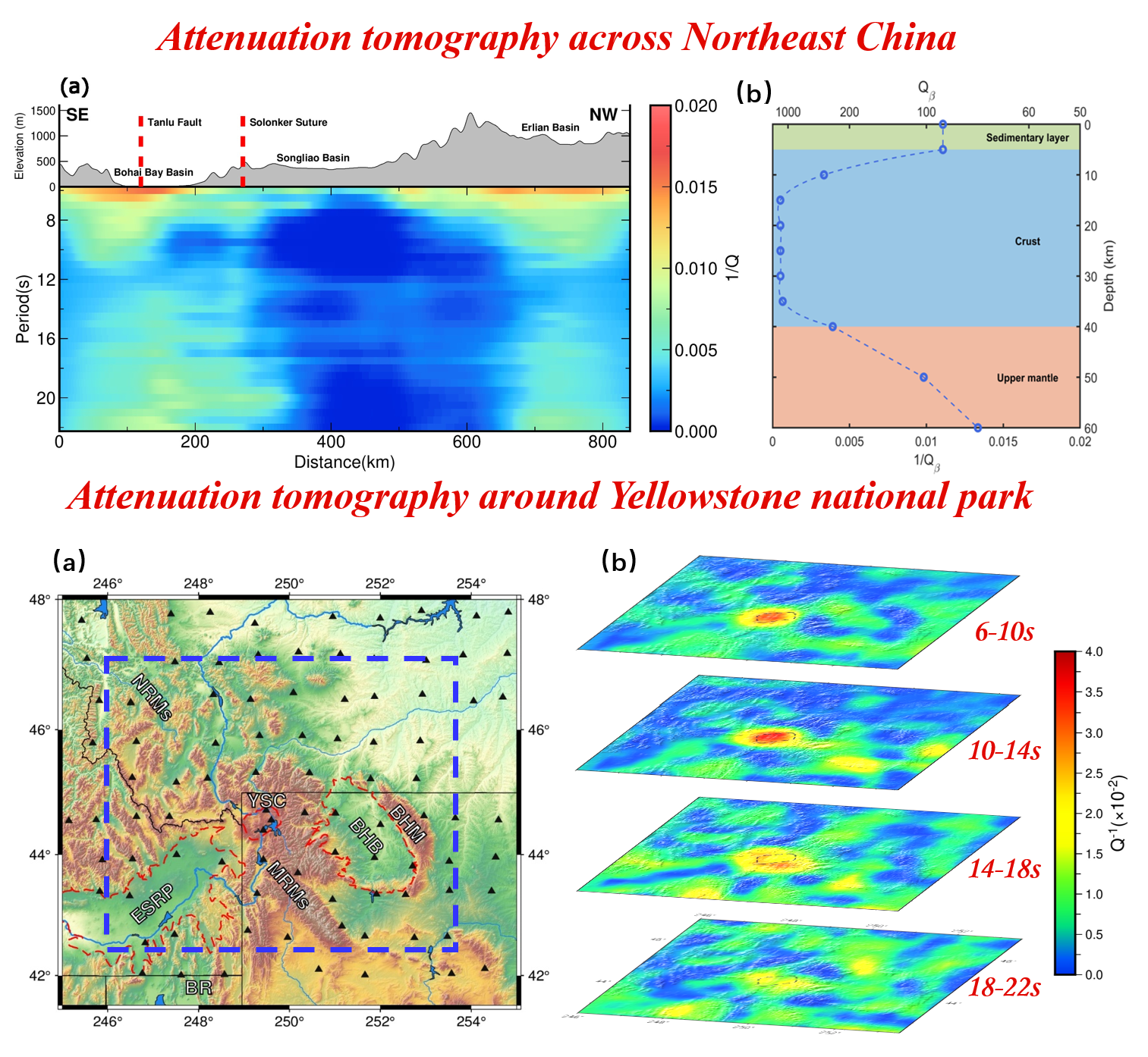
Although ambient noise interferometry has been extensively utilized for seismic velocity tomography, its applications to attenuation tomography remain limited. Compared to velocity, attenuation exhibits higher sensitivity to factors such as defect concentration, temperature, and the presence of molten components. As such, it is a powerful tool to image certain geological structures, which include magma chambers, potential crust flows, and fault zones. Nevertheless, the amplitude information is less robust than arrival times in EGFs. Therefore, to retrieve reliable attenuation, special preprocessing, and inversion methods should be applied.
Throughout the past two years, we summarized and further developed a comprehensive workflow for ambient noise attenuation tomography. To obtain high-quality EGFs and more accurate amplitude measurements, we have adopted the asynchronous temporal flattening (ATF) method in the data preprocessing stage. Additionally, we propose utilizing the symmetry of causal and anti-causal arrivals (t-symmetry) as an auxiliary criterion, along with SNR, to select reliable amplitude measurements. Finally, in the inversion, we joint constrain the noise intensity of the ambient wave field and Earth structure. To validate the effectiveness of the proposed approach, we have applied it to several regions, including Yellowstone National Park, Northeast China, and Southwest China. The obtained attenuation results correlate reasonably well with known geological structures, including basins, major faults, and magma chambers.
Imaging with nodal arrays
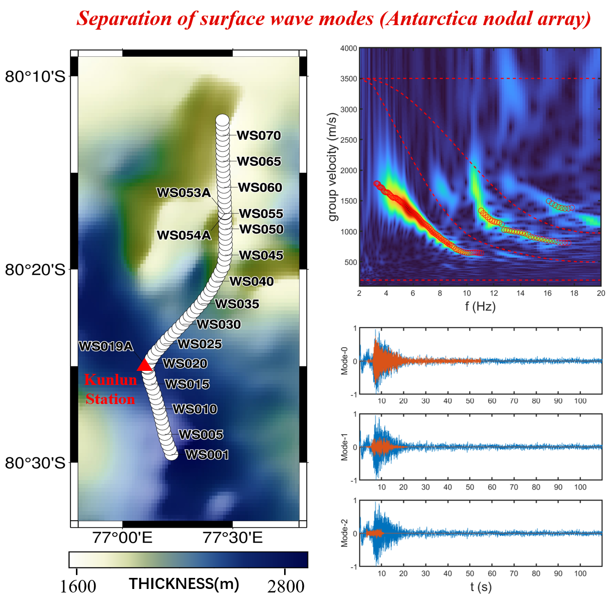
Dense nodal arrays provide an opportunity to image the fine structure several kilometers from the earth's surface. Recently, cooperating with the Chinese Antarctic Center of Surveying and Mapping, we deployed seismic nodal sensors near the Kunlun station (80°25′S, 77°06′E). Through noise interferometry, we noticed distinct higher modes of surface waves in this dataset. This phenomenon might be caused by 1) the large gradient of velocity from snow to ice in tens of meters near the surface (which acts like a basin), and 2) the strong high-frequency noise source from Kunlun station. The higher modes allow us to constrain the underground structure better, while also bringing troubles in dispersion curve measurement. To handle this problem, We have developed a method to separate the waveforms of different modes in the F-v domain. Now, the construction of the velocity profile is still going on.
Publications:
[1]. Hongrui Peng, Jiangtao. Rayleigh wave attenuation tomography based on ambient noise interferometry: methods and an application to Northeast China. (Submitted to GJI, in moderate review)
[2]. Hongrui Peng, Hok Sum Fok, Junyi Gong, and Lei Wang (2020). Improving Stage-Discharge Relation in The Mekong River Estuary by Remotely Sensed Long-Period Ocean Tides. Remote Sensing.